
Location
The “Dragišnica and Komarnica” Nature Park is located in the far northwestern part of the Municipality of Šavnik. It borders the Durmitor National Park and belongs to the cadastral municipalities of Grabovica, Komarnica, Duži, and Pošćenje. The total area of the park is 2,994.00 hectares.
History
At its session held on November 20, 2017, the Municipal Assembly of Šavnik adopted the Decision on proclaiming the “Dragišnica and Komarnica” Nature Park in Šavnik.
The company Nature Park “Dragišnica and Komarnica” LLC, as the managing authority, took over the management of the protected area from the Municipality of Šavnik on December 28, 2017.
Nature
Flora and Vegetation
The floristic diversity of Dragišnica and Komarnica Nature Park is exceptional and represents one of the key elements of its overall natural value. Over 1,000 plant species and subspecies have been recorded within the park, making it one of the floristically richest areas in Montenegro. This diversity is the result of complex geological and climatic factors, as well as the preservation of natural habitats, ranging from river valleys and gorges to mountain pastures and rocky terrains.
Vegetation develops vertically, from mesophilic deciduous forests and thermophilic communities in river valleys, through beech, fir, and black pine forests, to juniper communities, mountain meadows, and subalpine rocky areas.
The richness of the flora and vegetation in the Komarnica watershed, the Dragišnica forest reserve, and the surrounding area can be explained by the refugial character of these regions, which serve as significant centers for the conservation and development of native flora and vegetation. The Komarnica and Dragišnica areas show the presence of two main groups: Central-Southern European mountain species, Arctic-Alpine and Boreal species as primarily glacial chronoelements, and Southern European mountain species as tertiary chronoelements, with some variation in the relationship of the main chrono- and geo-elements from the high-mountain to mountain zone.
Fauna
The diversity of plant communities and various ecological factors have shaped the richness, dynamics, and distribution of fauna in this area. The lush development of forest stands, which alternate and intertwine with meadow, pasture, high-mountain, river, and canyon ecosystems, has enabled the development of a rich and diverse wildlife.
In our park, one can encounter the brown bear (Ursus arctos), grey wolf (Canis lupus), red fox (Vulpes vulpes), roe deer (Capreolus capreolus), chamois (Rupicapra rupicapra), Balkan lynx (Lynx lynx balcanicus), and many other species.
Sights
Nevidio Canyon
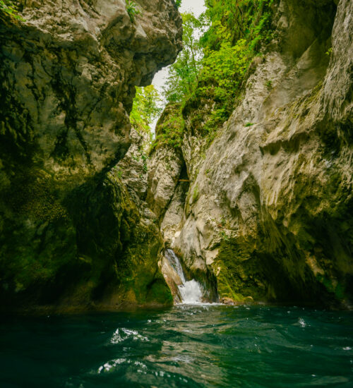
Nevidio Canyon is one of the most exciting and mysterious natural phenomena in Montenegro, and indeed in all of Europe. Located in the heart of the nature park, this unique canyon remained unknown and impassable to humans for a long time, until it was first fully conquered in 1965. Precisely because of its inaccessibility and hidden nature, it was given the name “Nevidio” (meaning Unseen), and is also known among locals as “Neviđbog” — a canyon that for centuries remained invisible and deeply concealed within stone.
Today, Nevidio is one of the most attractive destinations for adventure tourism in the region. Narrow passages, towering rock cliffs, crystal-clear water, and natural pools create a scene of incredible wilderness and beauty. In some places, the canyon is less than one meter wide, while the rock walls rise high above, creating a powerful sense of connection with nature.
Traversing the canyon requires good physical fitness, but with experienced guides and proper equipment, it provides an unforgettable experience full of adrenaline, challenge, and excitement. The journey through the canyon takes 3–4 hours, depending on water levels and the group’s fitness. The canyon is on average about 150 meters deep and approximately 2 kilometers long. The entrance to Nevidio Canyon is at around 935 meters above sea level, while the exit is at about 810 meters above sea level.
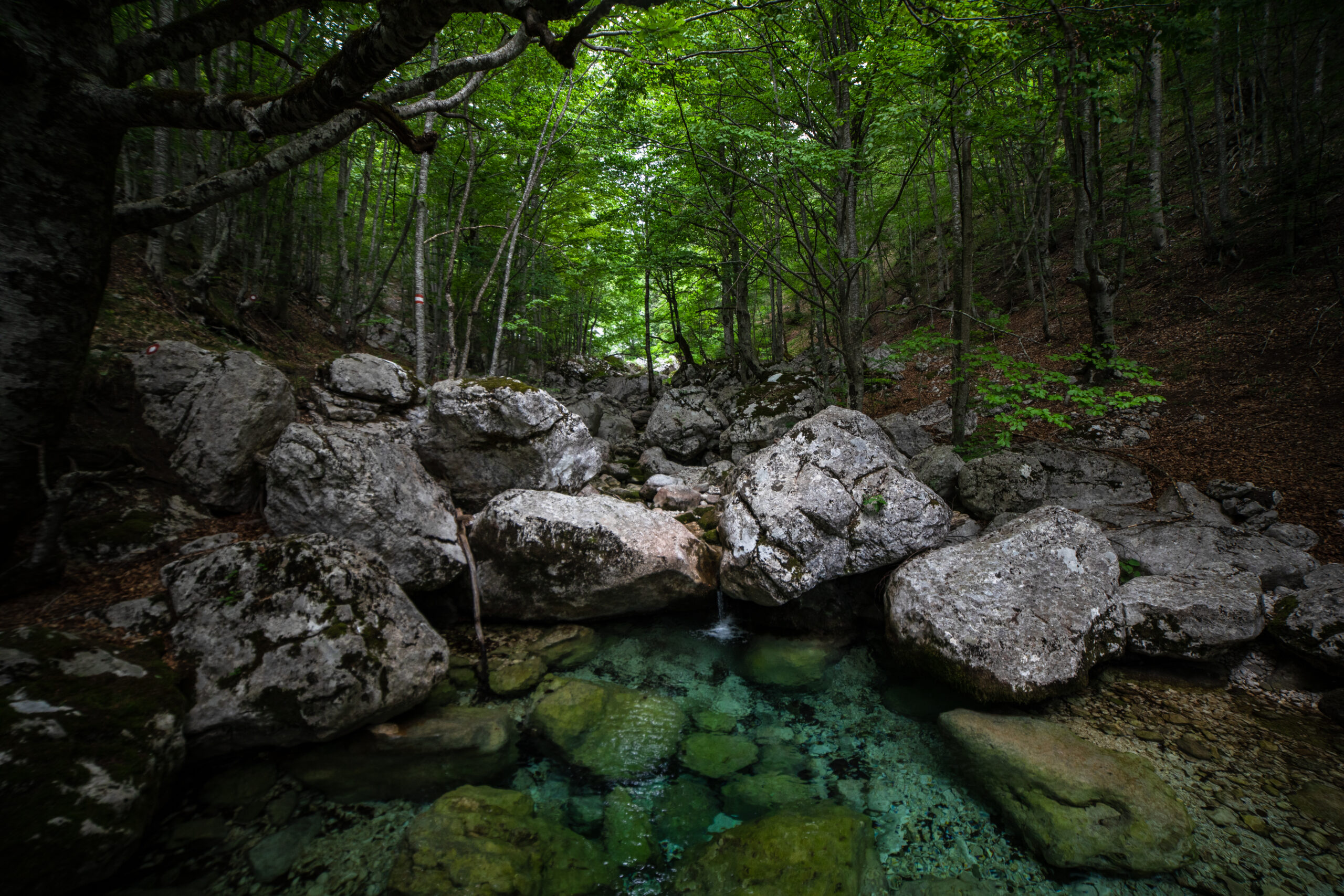
Dragišnica Forest Complex
The Dragišnica Forest Complex is located on the southern slopes of Durmitor, within Dragišnica and Komarnica Nature Park, and represents one of the best-preserved areas of mountain nature in Montenegro. It is situated at 1,475 m above sea level. Expansive coniferous and beech forests, rich biodiversity, and unique landscapes make Dragišnica an ideal destination for nature lovers, recreational walkers, photographers, and those seeking rest far from city noise.
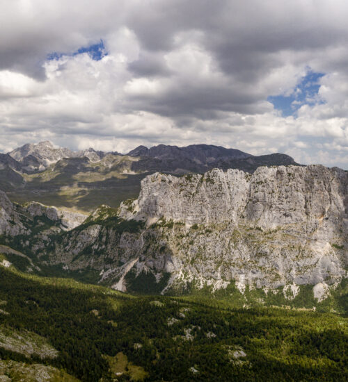
Boljske Grede represent one of the most recognizable and impressive landscapes of our park. These massive rock formations rise like natural walls, creating a dramatic scene that captivates every visitor. Steep cliffs, rugged rocks, and sharp ridges testify to the powerful natural forces that shaped this mountainous landscape.
The impressive ridges stretch for nearly 3.5 kilometers, with some rocks rising up to 700 meters high. Their highest peak, outside the park boundaries, reaches 2,091 m above sea level, while the highest peak within Dragišnica and Komarnica Nature Park, Ogorjeli krš, stands at 1,998 m. This area is truly a natural stone fortress: rugged, powerful, and magnificent in every season.
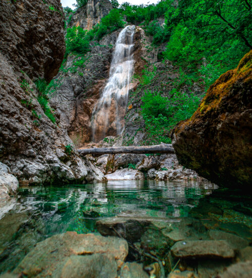
Skakavica Waterfall is one of the most beautiful natural jewels of our protected area. Surrounded by greenery and rocks shaped by water over centuries, the waterfall impresses with its height and energy. Crystal-clear water plunges down a steep cliff, creating a refreshing mist and a natural melody that is unforgettable.
This large seasonal waterfall, approximately 80 m high, is located at about 1,000 m above sea level. It becomes active during snowmelt and heavy rains when the surrounding springs swell. The waterfall is equally spectacular in winter, when freezing temperatures turn it into ice, presenting a unique attraction and challenge for climbers. Only when you hear the roar and feel the rushing flow will you fully appreciate its beauty and uniqueness.
Komarnica River
The Komarnica River rises beneath the southern slopes of Mount Durmitor, in the area of Dobri Do. It is formed by several springs, the most significant being Šarban (1,680 m above sea level) and Sopot (1,600 m above sea level). With a drainage basin covering 774 km² and a total length of 39.4 km, the river is characterized by numerous geomorphological and hydrological phenomena, among which the Nevidio Canyon holds a particularly prominent place.
Grabovica River
The Grabovica River is formed by the confluence of the Morava and Studena streams, which meet in the village of Grabovica at an elevation of 1,250 m above sea level. The lowest part of the valley is carved into Cretaceous limestone and ends in the Skakavica Waterfall, approximately 80 meters high, after which the Grabovica flows into the Komarnica River.
The Grabovica Canyon is located on the river of the same name, near the Nevidio Canyon. It is about one kilometer long. What makes this canyon unique is that almost its entire length is bathed in sunlight. Passing through the canyon is considered a multi-layered pleasure, as it consists of an exciting descent through beautiful waterfalls and pools.
Tourism
Canyoning
Canyoning in the Nevidio Canyon—one of the most spectacular natural attractions of the Dragišnica and Komarnica Nature Park—offers a unique blend of adrenaline, wilderness, and adventure through one of the deepest and most inaccessible canyons in Montenegro, and even Europe. This extraordinary natural phenomenon is known for its dramatic cliffs, narrow passages, and hidden cascades shaped throughout the year by the Komarnica River.
Hiking
Hiking in the Dragišnica and Komarnica Nature Park offers a unique experience for outdoor enthusiasts, combining high-mountain landscapes, impressive canyon zones, and wide panoramic viewpoints. Thanks to its exceptional geomorphological diversity and well-preserved natural environment, the park provides ideal conditions for recreational walkers, experienced hikers, and visitors eager to explore the authentic scenery of the Durmitor hinterland.
Cycling
Cycling in Dragišnica and Komarnica Nature Park offers visitors the opportunity to explore the diverse landscapes of this protected area in a dynamic and sustainable way. With its combination of mountain roads, forest paths, and plateaus stretching between canyons and mountain ranges, the park provides an excellent setting for both recreational and mountain biking.
Connectivity
The backbone of the transport network consists of the new main road Risan–Grahovo–Žabljak, sections of the regional roads R-5 and R-18, as well as a network of local roads.
1. R-5: Nikšić – Lukovo – Krnovo – Šavnik – Tušinja – Gornja Bukovica – Žabljak
2. R-18: Mioska – Semolj – Boan
Contact
Mail: